Flooding is a natural phenomenon that has significant social, economic, and environmental impacts. It is one of the most devastating natural hazards, causing extensive damage to property and infrastructure, loss of life, and disruption of essential services. In recent years, the frequency and intensity of floods have increased due to climate change, urbanization, and deforestation. Therefore, it is essential to adopt proactive measures to mitigate the risks associated with floods.
This comprehensive guide will delve into the critical aspects of hydrological modeling and flood studies, including flood risk assessments, identification of flood-prone areas, and recommendations for flood mitigation.
We will explore best practices in urban planning, drainage design and the implementation of effective flood control measures.
For implementation inspiration, we will showcase actual cities and regions where flood studies have been successfully conducted, and risks have been mitigated.

Hydrological Modeling and Flood Studies: An Overview
Hydrological modeling is a powerful tool that simulates the movement of water through the hydrological cycle. It involves the use of mathematical models to represent the complex interactions between rainfall, runoff, infiltration, evapotranspiration, and groundwater flow. Flood studies utilize hydrological models to assess the magnitude and frequency of floods, identify flood-prone areas, and evaluate the effectiveness of flood mitigation measures.
Importance of Hydrological Modeling and Flood Studies
Hydrological modeling and flood studies play a crucial role in flood risk management. They provide valuable insights into the behavior of water systems, enabling engineers and planners to make informed decisions regarding flood mitigation and land use planning. The key benefits of hydrological modeling and flood studies include:
Accurate Flood Risk Assessment: Hydrological models can simulate various flood scenarios, providing accurate estimates of flood depths, velocities, and extents. This information is crucial for assessing the potential impacts of floods and identifying vulnerable areas.
Identification of Flood-Prone Areas: Flood studies help identify areas susceptible to flooding. This information is essential for land use planning and zoning regulations, ensuring that development is restricted in high-risk areas.
Evaluation of Flood Mitigation Measures: Hydrological models can be used to evaluate the effectiveness of various flood mitigation measures, such as dams, levees, and flood control channels. This enables decision-makers to select the most appropriate and cost-effective solutions.
Improved Emergency Preparedness and Response: Flood studies provide valuable data for developing emergency preparedness and response plans. This information helps ensure that communities are prepared to respond effectively to flood events, minimizing the impacts on life and property.
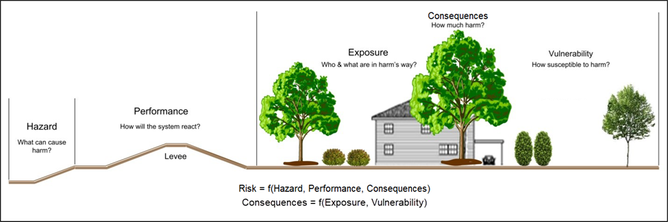
Flood Risk Assessment
Flood risk assessment is a systematic process that involves identifying, analyzing, and evaluating the potential impacts of floods. It is an essential component of flood risk management, providing a basis for decision-making regarding flood mitigation and land use planning. The key steps involved in flood risk assessment include:
Hazard Identification: This involves identifying the sources of flood hazards, such as rivers, streams, lakes, and coastal areas. It also includes assessing the magnitude and frequency of potential floods.
Vulnerability Assessment: This involves identifying the elements at risk from floods, such as people, property, infrastructure, and the environment. It also includes assessing the susceptibility of these elements to flood damage.
Risk Analysis: This involves combining the hazard and vulnerability assessments to estimate the potential impacts of floods. It also includes evaluating the uncertainty associated with these estimates.
Risk Evaluation: This involves comparing the estimated flood risks with acceptable levels of risk. It also includes considering the social, economic, and environmental consequences of floods.
Determination of Flood-Prone Areas
The determination of flood-prone areas is a critical aspect of flood risk management. It involves identifying areas susceptible to flooding based on various factors, such as topography, hydrology, land use, and climate. Several methods can be used to identify flood-prone areas, including:
Hydrological Modeling: Hydrological models can simulate the movement of water through a watershed, providing estimates of flood depths and extents. This information can be used to identify areas susceptible to flooding.
Floodplain Mapping: Floodplain maps delineate areas that are likely to be inundated during a flood event. These maps are based on historical flood data, hydrological modeling, and topographic surveys.
Remote Sensing and Geographic Information Systems (GIS): Remote sensing technologies, such as satellite imagery and aerial photography, can be used to identify areas that have been flooded in the past. GIS can be used to integrate this information with other data, such as topography and land use, to identify flood-prone areas.

Recommendations for Flood Mitigation
Flood mitigation involves implementing measures to reduce the risks associated with floods. It is a multi-faceted approach that includes structural and non-structural measures. Some of the key recommendations for flood mitigation include:
Structural Measures:
- Dams and Reservoirs: Dams and reservoirs can be used to store floodwaters, reducing the peak flow downstream.
- Levees and Floodwalls: Levees and floodwalls can be constructed along rivers and streams to prevent floodwaters from inundating adjacent areas.
- Flood Control Channels: Flood control channels can be constructed to divert floodwaters away from populated areas.
- Detention and Retention Basins: Detention and retention basins can be used to temporarily store floodwaters, reducing the peak flow downstream.
Non-Structural Measures:
- Floodplain Management: Floodplain management involves regulating development in flood-prone areas to minimize flood risks.
- Flood Warning Systems: Flood warning systems provide timely information about impending floods, enabling people to take necessary precautions.
- Flood Insurance: Flood insurance provides financial protection against flood damage.
- Community Preparedness and Education: Community preparedness and education programs help people understand the risks associated with floods and take necessary precautions.
If you need professional help in conducting the hydrological assessment and flood studies for your city or property, we’d love to speak with you and see how we can serve you best.
Should you wish to simply send an inquiry about other services including environmental engineering, geotechnical studies, consulting, EIA report preparation etc, you may do so by clicking the button below and our account manager shall get back to you within two (2) business days:
Best Practices in Urban Planning and Drainage Design
Urban planning and drainage design play a crucial role in flood risk mitigation. By incorporating best practices into these processes, the impacts of floods can be significantly reduced. Some of the key best practices include:
- Green Infrastructure: Green infrastructure, such as rain gardens, bioswales, and green roofs, can be used to manage stormwater runoff, reducing the burden on traditional drainage systems.
- Permeable Pavements: Permeable pavements allow stormwater to infiltrate into the ground, reducing runoff and improving groundwater recharge.
- Sustainable Drainage Systems (SuDS): SuDS mimic natural drainage patterns, using a combination of green and grey infrastructure to manage stormwater runoff.
- Flood Risk Assessments in Land Use Planning: Flood risk assessments should be incorporated into land use planning and zoning regulations to ensure that development is restricted in high-risk areas.
- Public Participation: Public participation is essential in the planning and design of flood mitigation measures. This ensures that the needs and concerns of the community are considered.

Case Studies: Cities and Areas with Successful Flood Studies and Mitigation
Several cities and regions worldwide have successfully implemented flood studies and mitigation measures, significantly reducing the risks associated with floods. Some notable examples include:
The Netherlands: The Netherlands is a global leader in flood risk management, having implemented extensive flood control measures, including dams, levees, and flood control channels. The Dutch Delta Works is a prime example of a successful flood mitigation project.
Singapore: Singapore has adopted a comprehensive approach to flood risk management, incorporating green infrastructure, sustainable drainage systems, and public education programs. The Active, Beautiful, Clean Waters program is a key initiative that has transformed Singapore’s waterways into vibrant and resilient blue-green spaces.
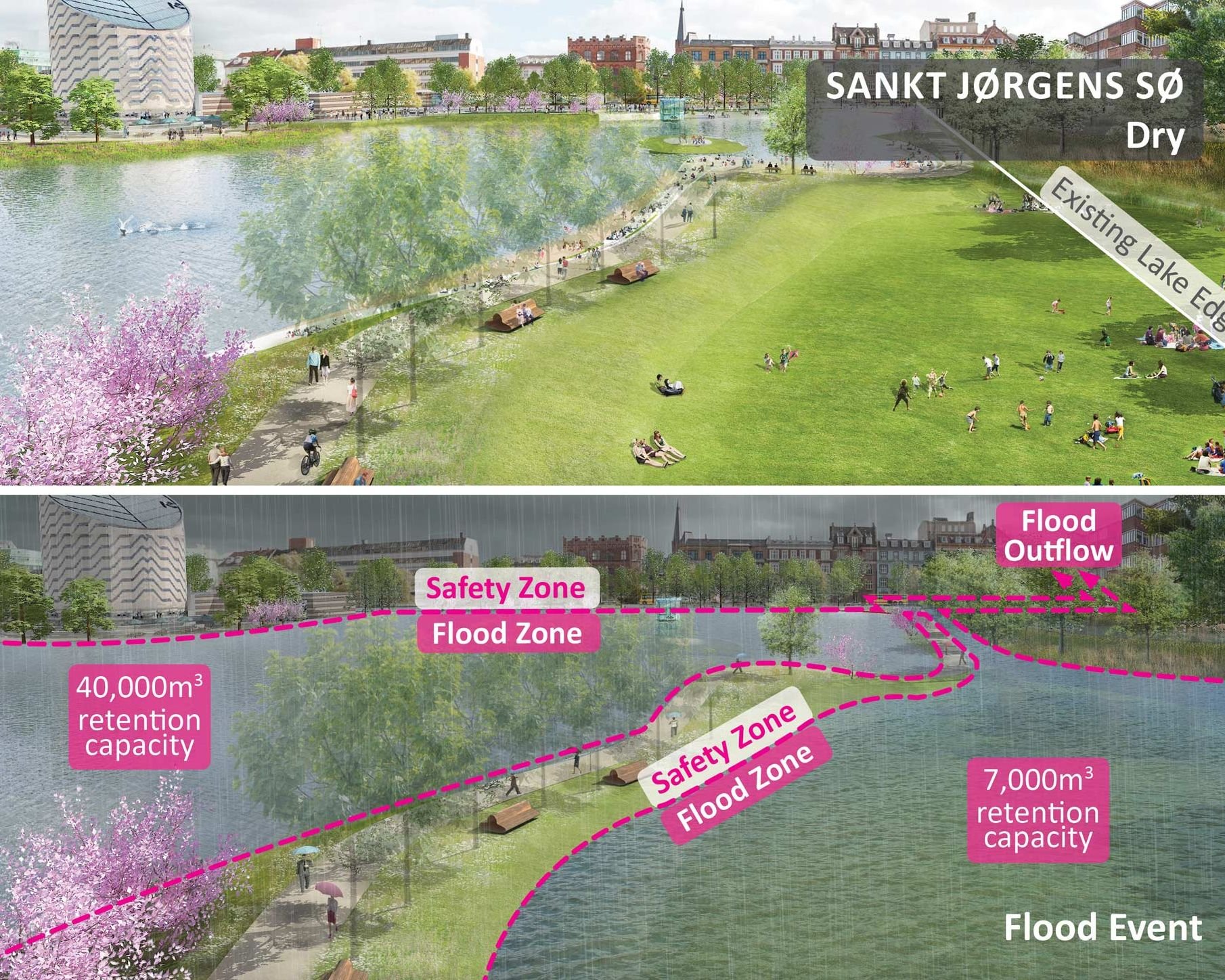
Copenhagen, Denmark: Copenhagen has implemented innovative solutions to manage stormwater runoff and mitigate flood risks. The Cloudburst Management Plan is a comprehensive strategy that utilizes green infrastructure, detention basins, and flood control channels to manage heavy rainfall events.
TL; DR
Hydrological modeling and flood studies are indispensable tools for flood risk management. They provide valuable insights into the behavior of water systems, enabling engineers and planners to make informed decisions regarding flood mitigation and land use planning. By adopting proactive measures, such as implementing best practices in urban planning and drainage design, and incorporating flood risk assessments into land use planning, the impacts of floods can be significantly reduced. The case studies presented in this guide demonstrate that successful flood risk management is achievable through a combination of structural and non-structural measures, public participation, and innovative solutions.
It is crucial to recognize that flood risk management is an ongoing process. As climate change continues to impact the frequency and intensity of floods, it is essential to adapt and improve our flood mitigation strategies. By investing in hydrological modeling and flood studies, we can better understand the risks associated with floods and develop effective solutions to protect our communities and the environment.
References & Resources
- Intergovernmental Panel on Climate Change (IPCC). (2021). Climate Change 2021: The Physical Science Basis. Contribution of Working Group I to the Sixth Assessment Report of the Intergovernmental Panel on Climate Change. Cambridge University Press.
- United Nations Office for Disaster Risk Reduction (UNDRR). (2015). Sendai Framework for Disaster Risk Reduction 2015-2030.
- World Meteorological Organization (WMO). (2018). Flood Management: Integrated Approaches.
- United States Environmental Protection Agency (EPA). (2021). National Stormwater Calculator.
- Federal Emergency Management Agency (FEMA). (2021). Floodplain Management Requirements.