The Myth, the Typhoon, and the Search Query
Every time a powerful typhoon barrels toward the Philippines, a predictable and unique social media phenomenon occurs. As the storm makes landfall on Luzon’s eastern seaboard, satellite images capture the cyclonic system colliding with the island’s mountainous terrain. Inevitably, images showing the storm’s eye “closing” or its structure “breaking” go viral.
With this comes a nationwide outpouring of gratitude. Hashtags like #SaveSierraMadre trend, and millions of Filipinos, particularly in the inland capital of Metro Manila, “thank” the Sierra Madre for its protection. This sentiment is rooted in generations of cultural belief and even mythology, which speaks of a mother-mountain protecting her children from the winds. Recent events, such as Super Typhoon Karding (Noru) in 2022 and the more recent Super Typhoon Uwan (Fung-wong) , have only amplified this narrative.
But amid the digital applause, a more troubling reality emerges. While inland residents post their thanks, communities along the coast—in provinces like Aurora and Isabela— are left to survey "immense damage". This disconnect has led experts on the ground to issue sharp corrections.
American storm chaser Josh Morgerman, documenting Typhoon Uwan from Aurora, called this narrative “misinformation”. He stated a crucial, often-overlooked fact: “The Sierra Madre Mountains weaken typhoons. But this only happens after communities on Luzon’s east coast take the full force”.
This conflict between popular myth and scientific reality is the central question of this report. As an environmental engineering and consulting firm, GreenDev Solutions believes in data-driven analysis for effective climate resilience. The public is actively searching for answers:
Does the Sierra Madre really stop typhoons?
The answer is not a simple “yes” or “no.” It is a complex, nuanced “yes, but…”
This report provides an unbiased, scientifically-backed analysis of the Sierra Madre’s true role. It moves beyond mythology to examine the meteorological mechanisms, data-driven case studies, the profound anthropological context, and the critical present-day threats that are compromising this vital natural infrastructure.
The Science of a Storm vs. a Mountain: How a Typhoon Really Interacts with the Sierra Madre
To understand the Sierra Madre’s role, one must first understand its physical properties and the mechanisms by which it interacts with a tropical cyclone. The popular image of a “wall” blocking a storm is a misleading oversimplification. The interaction is far more complex, involving two primary, and often opposing, meteorological forces.
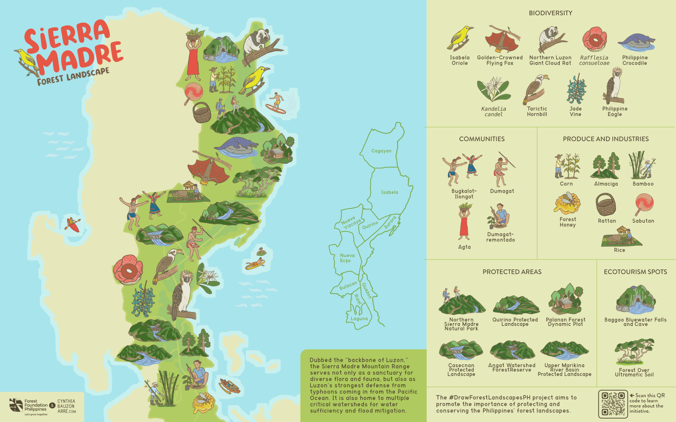
A Geological Profile: The "Backbone of Luzon"
The Sierra Madre is the longest mountain range in the Philippines. It is the “backbone of Luzon,” a massive geological feature stretching over 540 kilometers from Cagayan province in the north to Quezon province in the south.
This range, which rises to peaks of approximately 1,500 to 2,000 meters , forms the island’s primary eastern barrier against the Pacific Ocean, the birthplace of most typhoons that enter the Philippine Area of Responsibility (PAR)

The Two-Faced Mechanism: Friction vs. Lift
When a typhoon—a heat engine powered by the warm, moist air over the ocean —makes landfall, it is subjected to two primary geological influences.
Mechanism 1: Surface Friction, aka The "Brake" Effect
A typhoon’s strength is rapidly sapped when it moves over land. This is due to two factors: the loss of its warm-water energy source and the introduction of “surface friction”. The “mountainous terrain” of the Sierra Madre acts as a physical “brake” , introducing intense friction that disrupts the storm’s low-level circulation and “spins down” its winds.
Crucially, this friction is not just from the rock itself. A key meteorological concept is “aerodynamic roughness length,” a measure of how much friction a surface provides. Research shows that forests are exceptionally effective windbreaks because they have a very high aerodynamic roughness length.
Therefore, the dense forest cover of the Sierra Madre is a more critical—and degradable—component of this “brake” than the mountain’s rocky slopes alone. This friction mechanism is the primary reason typhoons weaken as they traverse the landmass.
Mechanism 2: Orographic Lift, aka The "Rain-Maker"
This is the second, more dangerous mechanism. As a typhoon’s vast, moisture-laden circulation system slams into the mountain range, the air has nowhere to go but up. This “forced air lifting,” known as “orographic lift,” pushes the moist air high into the atmosphere. As this air rises, it cools and condenses, dramatically enhancing and concentrating rainfall.
This is why meteorological stations in mountainous regions consistently report the highest rainfall totals during storms. More importantly, this effect is not limited to the windward (eastern) side.
The orographic lift effect can increase rainfall on the leeward (western) side of the mountain—including Metro Manila—which can contribute to catastrophic, widespread flooding. The devastating floods of 2009’s Typhoon Ondoy (Ketsana) are a tragic example of orographically-enhanced precipitation.
The Scientific Verdict: The 2023 Bagtasa & Racoma Study
This complex, dual-impact reality was the subject of a landmark 2023 study published in the Philippine Journal of Science. The paper, “Does the Sierra Madre Mountain Range in Luzon Act as a Barrier to Typhoons?” was authored by Dr. Gerry Bagtasa and Dr. Bernard Alan Racoma of the University of the Philippines (UP) Institute of Environmental Science and Meteorology.
Their research provides the most definitive scientific answers to date. Using the Weather Research and Forecasting (WRF) model, they simulated typhoons striking Luzon with the Sierra Madre (SMMR) and Cordillera (CMR) ranges present, and then again with the mountains digitally flattened.
Their findings are profound and debunk many popular myths:
Finding 1: No Immediate "Shield"
The study showed that typhoons maintain their intensities upon landfall and during the first six hours over land, regardless of the mountains’ presence. This directly refutes the idea that the Sierra Madre acts as an instant “wall” that “breaks” the storm on contact. The weakening effect is delayed, a result of prolonged friction over the entire landmass.
Finding 2: The Height Fallacy
Dr. Bagtasa explains that the SMMR, at only 1.5 to 2 kilometers tall, cannot physically “block” a 15-kilometer-high typhoon. The interaction is not a “wall” hitting a “ball”; it is a surface-level interaction, driven by the friction of the land and forests.
Finding 3: The Wind vs. Rain Trade-off
This is the study’s most critical finding:
While the SMMR does eventually help reduce wind, it simultaneously enhances rainfall for the rest of Luzon.
The study found that for areas on the western side, including Metro Manila, the SMMR increases rainfall by 23% to 55%. This is a net-negative impact, as experts note that “most TC-related damages are water/rainfall related”.
Finding 4: The Cagayan Valley Exception

The only region for which the SMMR acts as an effective, unambiguous “barrier” (reducing both wind and rainfall) is the Cagayan Valley, which is nestled between the SMMR and the Cordilleras.
Finding 5: The Cordillera is a Better Barrier

The study also concluded that the (further inland) Cordillera Mountain Range “has a larger hazard-mitigating effect” on wind strength than the Sierra Madre.
In short, the science is clear. The Sierra Madre is not a uniform shield:
It is a geographically complex feature that creates a "geographic lottery" of risk: it protects the Cagayan Valley, exposes the eastern coast to a "full force" blow, and actively worsens the flood risk for Metro Manila by amplifying rainfall.
A Wall That Bleeds: Data-Driven Case Studies in Typhoon Weakening
While the Bagtasa & Racoma study proves the delayed and complex nature of the weakening, historical data from PAGASA and other meteorological agencies confirms that the cumulative effect of crossing the Luzon landmass, initiated by the Sierra Madre, is a significant, measurable reduction in typhoon wind strength.
The following case studies of three of the most powerful typhoons in recent history provide clear, data-driven evidence of this “braking” effect.
| Typhoon (Local / Int'l Name) | Date | Pre-Landfall Intensity (Max. Sustained Winds, 10-min, PAGASA) | Landfall Location | Post-Luzon-Crossing Intensity (Max. Sustained Winds) | Wind Speed Reduction (10-min) |
|---|---|---|---|---|---|
Super Typhoon Rolly (Goni) | Oct 2020 | 220 km/h (10-min) (Reached 315 km/h 1-min) | Catanduanes / Southern Luzon | Degraded to Tropical Storm | Massive |
Super Typhoon Karding (Noru) | Sep 2022 | 195 km/h | Polillo Islands / Dingalan, Aurora (SMMR) | “Weakened into a typhoon” | Significant |
Super Typhoon Ompong (Mangkhut) | Sep 2018 | 205 km/h | Baggao, Cagayan | 145 km/h (upon exiting PAR) | 60 km/h |
Case Study 1: Super Typhoon Rolly (Goni, 2020)
The Storm: Super Typhoon Rolly is one of the most powerful storms ever recorded, making history as the strongest tropical cyclone at landfall based on 1-minute sustained winds.
Metrics & Interaction: Rolly made its first landfall in Catanduanes with 10-minute sustained winds of 220 km/h and 1-minute sustained winds of a staggering 315 km/h. As it tracked across Southern Luzon, reports confirm it “rapidly weakened while it moved over the Sierra Madre mountain range”.
The Result: The interaction with the rugged terrain of the Bicol Peninsula and Southern Sierra Madre was so catastrophic for the storm that it emerged into the West Philippine Sea as a mere Tropical Storm. This represents one of the most dramatic examples of topographic-induced storm disruption, showcasing the immense energy dissipation caused by the landmass.
Case Study 2: Super Typhoon Karding (Noru, 2022)
The Storm: Super Typhoon Karding was infamous for its “explosive intensification” in the 24 hours before landfall. It was this storm that re-ignited the viral “Thank you, Sierra Madre” trend.
Metrics & Interaction: Karding reached a peak as a Super Typhoon with 10-minute sustained winds of 195 km/h. It made its second, and most significant, landfall in Dingalan, Aurora, a municipality directly on the Sierra Madre range.
The Result: A consolidated rapid assessment report explicitly states: “After traversing the Sierra Madre Mountain range, the storm weakened into a typhoon”. Satellite images clearly showed the storm’s structure becoming disrupted as it “significantly weakened” during its 9-hour passage over Luzon.
Case Study 3: Super Typhoon Ompong (Mangkhut, 2018)
The Storm: Ompong was a massive storm, nearly 900 kilometers in diameter, that struck Northern Luzon.
Metrics & Interaction: It made landfall in Baggao, Cagayan. PAGASA’s final report states its peak intensity (10-minute sustained winds) was 205 km/h , which it maintained as it entered the PAR.
The Result: The official PAGASA report provides a clear, data-driven conclusion: “Interaction with the rugged terrain of Northern Luzon after landfall caused the typhoon to weaken significantly“.
When Ompong exited the PAR at 9:00 PM on September 15, its maximum sustained winds had been reduced to 145 km/h. This is a quantifiable 60 km/h reduction in wind speed.
However, the very same report highlights the deadly paradox: “Interaction with the rugged terrain… have aggravated the nature of rainfall, which caused flooding and landslides especially in the mountainous Cordillera Administrative Region”.
This case study perfectly illustrates the scientific reality:
The mountains did weaken the wind, but they also aggravated the rainfall, leading to devastating landslides.
The "Mother" of the Mountain: The Anthropological Reality of the Sierra Madre
The query for this report rightly included an “anthropological” component. This is not just a scientific curiosity; it is the most critical and overlooked aspect of the Sierra Madre’s conservation. The mountain range is not an empty, wild park. It is a home, a culture, and the ancestral domain of its original inhabitants.
The Dumagat-Remontados: Ancestral Stewards

The Sierra Madre is the ancestral land of several Indigenous Peoples (IPs), most notably the Dumagat-Remontados.
Their very names tell their story: “Dumagat” is derived from the word dagat (sea), and “Remontado” is a Spanish term meaning “to flee to the hills”.
They are a people of the coast who, over centuries of pressure from colonization, retreated into the mountains.
Their culture is built on a deep, spiritual, and sustainable connection to the land. For generations, they have practiced a semi-nomadic subsistence lifestyle through hunting, fishing, and a form of rotational kaingin (swidden agriculture) that is intrinsically linked to their worldview.
Their relationship with the land is not one of extraction, but of stewardship. This is all protected—in theory—by the Indigenous Peoples’ Rights Act of 1997 (IPRA).
Guardians on the Front Lines
While inland citizens post hashtags, the Dumagat-Remontados are the true “guardians of the forest”. They are the de facto conservation stewards who, with partner organizations, are establishing Community Conservation and Protection Plans (CCPP) and serving as forest rangers, often at great personal risk.
A bitter irony highlighted in ethnographic studies is that while government agencies and NGOs rely on the Agta (a Dumagat group) to report illegal activities, they are often left without support. They are “pushed to stand up against illegal activities without… formal deputization,” left to confront armed illegal loggers with no authority or protection. Their requests for assistance from local government units or the Department of Environment and Natural Resources (DENR) are often “never followed up”.

This reveals a profound disconnect. The urban call to “#SaveSierraMadre” often erases the people already there, doing the saving. Any serious conservation or development strategy that does not center the ancestral domain rights of the Dumagat-Remontados is not only unjust, but it also actively undermines the most effective and dedicated conservation force on the ground.
The Present State: How We Are Tearing Down Our Own Shield
The scientific consensus is that the forest cover of the Sierra Madre is its most critical protective feature, providing the “friction” that weakens wind and the “sponge” that absorbs the enhanced rainfall to prevent catastrophic floods and landslides.
It is precisely this feature that is being systematically destroyed.
The Historical Wound & Present Degradation
The destruction of Philippine forests is one of the 20th century’s great ecological tragedies. In 1900, the Philippines had 21 million hectares of forest. Today, only around 3 million hectares remain, with barely 800,000 hectares of primary, old-growth forest. During the 1970s and 1980s, the country lost an average of 2.5% of its forests annually, a rate three times the global average.

This devastation is not just history; it is the present. A 2020 study assessing the effectiveness of the government’s National Greening Program (NGP) found “no significant gain” in forest cover in Luzon, the Sierra Madre, or the Cordillera between 2001 and 2018. The reason is a grim stalemate: the rate of deforestation continues to cancel out the gains from reforestation.
More recent analysis, using Google Earth Engine to monitor the Southern Sierra Madre (in General Nakar, Quezon, and Rodriguez, Rizal), confirmed this “declining pattern” between 2016, 2019, and 2022, as forested lands are continually converted to shrublands. The drivers identified by community mapping are a mix of subsistence and commercial pressures: kaingin (for agricultural expansion), infrastructure extension, timber poaching, small-scale mining, and charcoal making.
The "Legal" Threats: Government-Sanctioned Projects
While illegal logging remains a “primary reason” for degradation , the most significant, large-scale, and permanent threats to the Sierra Madre are now government-sanctioned infrastructure projects.
Project 1: The Dinapigue Mining Controversy (Isabela)
Context: In May-June 2025, satellite images showing large-scale mining operations in Dinapigue, Isabela, went viral, sparking massive public outrage.
The Official Clarification: In the interest of an unbiased report, the official government response is critical. The DENR-Mines and Geosciences Bureau (MGB) quickly clarified the legal status of the project.
- The operator, Dinapigue Mining Corporation (DMC) (a subsidiary of Nickel Asia), is operating legally.
- Its Mineral Production Sharing Agreement (MPSA) is valid until 2032.
- Its Environmental Compliance Certificate (ECC) is valid.
- Crucially, the DENR-MGB stated that the operation is OUTSIDE the boundaries of the Northern Sierra Madre Natural Park (NSMNP) and its buffer zone.
The Engineering Reality: This legal clarification, while important, is irrelevant from a meteorological and engineering perspective. A typhoon’s interaction with the land is governed by physics, not legal maps.
The “aerodynamic roughness” that provides the “brake” effect is lost regardless of whether the forest is removed legally or illegally. This legal operation, by removing forest cover, is actively degrading the region’s climate resilience, even if it is “outside the park.”
Project 2: Future Energy Projects
The pressure on the eastern seaboard is systemic. The Renewable Energy (RE) Act of 2008 is driving new development. This includes the Alabat Island Wind Power Project in Quezon and several “awarded” hydropower contracts in Rizal and Quezon, including one to the Sierra Madre Water Corp.. These projects indicate a sustained, long-term industrialization pressure on the mountain range.
A Collaborative Path Forward: Public and Private Sector Solutions
Addressing the deforestation of the Sierra Madre requires a collaborative approach that moves beyond acknowledging the problem to actively participating in the solution. Government, private corporations, and civil society are increasingly partnering to restore this critical ecosystem.

The government’s flagship reforestation initiative is the Enhanced National Greening Program (ENGP). This program aims to reforest the millions of hectares of denuded and degraded forestland across the Philippines and actively encourages private sector investment.
The NGP is designed for collaboration, inviting companies, NGOs, and civil society to join as volunteer planters, long-term plantation stewards, or donors. For corporations, participation is a direct way to invest in watershed rehabilitation and achieve carbon neutrality goals. Mechanisms for private sector involvement include:
Adopt-a-Forest/Adopt-a-Mountain: Companies can enter into agreements, such as a Memorandum of Agreement (MOA) with the DENR, to “adopt” a specific area for reforestation. This model is used by companies like URC to rehabilitate watersheds and by mining companies to fulfill seedling replacement requirements.
Direct Partnership: Corporations can partner directly with the DENR or with community organizations to fund and implement planting and maintenance activities.

Corporate and NGO-Led Initiatives in the Sierra Madre
This collaborative model is already active in the Sierra Madre. Numerous companies have partnered with non-profits and the DENR to fund reforestation in the region:
Corporate Partnerships: Companies like Meralco, Toyota , Siemens, Opentext, and Digital Edge have all funded and participated in tree-planting activities, planting thousands of native seedlings in degraded areas of the Sierra Madre, particularly in the Laguna-Quezon Land Grant in Siniloan.
NGO-Led Programs:
Haribon Foundation: Through its “Adopt-A-Seedling” Program, Haribon partners with corporations like Sourcefit and the Tourism Promotions Board to restore forests. These partnerships have planted thousands of native tree seedlings in areas like Mt. Batolusong in Tanay, Rizal, which is part of the Sierra Madre range.
Masungi Georeserve: The Masungi Georeserve Foundation entered a landmark agreement with the national government to restore and rewild 2,700 hectares of degraded land in Rizal. This youth-led project has successfully planted over 60,000 native trees, demonstrating a scalable and effective model for ecosystem restoration.
These initiatives provide a clear pathway for companies and individuals to move from passive awareness to active participation in restoring the forest cover that constitutes the Sierra Madre’s true protective power.
Conclusion: Protecting the Forest, Not the Myth
We return to the central question: Does the Sierra Madre protect Luzon from typhoons?
The scientific answer is a definitive “Yes, but…”
Yes
The combined landmass of Luzon, with the Sierra Madre as its first barrier, measurably weakens the wind intensity of powerful typhoons. The data from Super Typhoons Rolly, Karding, and Ompong is undeniable: these storms were “significantly weakened” by their passage, with Ompong showing a 60 km/h reduction in wind speed and Rolly degrading from the strongest-ever-landfalling cyclone to a mere tropical storm.
But,
This protection is not a shield. It does not save the eastern coast. As Josh Morgerman stated, the coast must “take the full force” before the weakening begins. This “protection” for inland areas comes at the cost of the east coast’s devastation.
But,
This protection is dangerously selective. Due to orographic lift, the mountain range actively worsens the flood risk for western areas, including Metro Manila, by enhancing rainfall by 23-55%.
This report's most critical finding is that the true "shield" is not the mountain, but its forest cover.
The forest provides the “aerodynamic roughness” that acts as the primary “brake” on wind. The forest acts as a “sponge,” absorbing and slowing the runoff from the orographically-enhanced rain, thereby mitigating the catastrophic floods and landslides that cause the most damage.
And this true shield is under pressure. The deforestation rate is cancelling out reforestation efforts. This alarming reality has intensified calls for unified action. In response to recent deforestation, lawmakers have renewed calls to create bodies like the Sierra Madre Development Authority, specifically tasked with restoring the region’s forest cover. This highlights a critical need for strong, continued collaboration between government agencies like the DENR, private sector partners, and local NGOs to protect and restore these vital natural resources.
As the 2023 UP study concludes, the public discourse must change. The authors state, “we should instead shift the discourse to protecting these mountain ranges from anthropogenic impacts”.
This is the real meaning of “#SaveSierraMadre“.
As an environmental engineering and consulting firm, GreenDev Solutions advocates for a national resilience strategy based on this scientific reality.
Protecting the Sierra Madre is the most effective climate resilience project for Luzon. This requires:
Prioritizing Forest Conservation: A national commitment to ending deforestation, not just offsetting it. This is essential to maintain the “surface friction” that weakens winds and the “forest sponge” that mitigates floods. This can be achieved through collaborative efforts like the National Greening Program and private-public partnerships.
Centering the Indigenous Stewards: Recognizing that the Dumagat-Remontados are the most effective frontline conservationists. Their ancestral domain rights must be the central pillar of any conservation or development policy in the region.
The Sierra Madre is not a mythical, indestructible wall. It is a living, vulnerable, and vital ecosystem—a critical carbon sink, a hotspot of biodiversity , and the ancestral home of a people.
Protecting it is not mythology; it is the soundest engineering and environmental policy for the 21st century.

SOURCES & CITATIONS:
- https://www.abs-cbn.com/news/health-science/2025/11/10/sierra-madre-other-mountains-guardians-of-luzon-what-the-science-says-2146
- https://www.adb.org/sites/default/files/project-documents/48325-001-iee.pdf
- https://www.alternergy.com/alabat
- https://www.cabidigitallibrary.org/doi/10.5555/20240052345
- https://cebudailynews.inquirer.net/669133/does-the-sierra-madre-really-stop-typhoons
- https://climate.gov.ph/news/934
- https://www.context.news/money-power-people/indigenous-filipinos-fight-plans-to-build-a-dam-on-their-land
- https://earthobservatory.nasa.gov/images/147476/devastating-storm-hits-the-philippines
- https://earthobservatory.nasa.gov/images/150399/noru-strikes-the-philippines
- https://earthobservatory.nasa.gov/images/92761/typhoon-mangkhut-reaches-luzon
- https://eia.emb.gov.ph/wp-content/uploads/2019/08/Kaliwa-Dam_Executive-Summary.pdf
- https://en.wikipedia.org/wiki/Deforestation_in_the_Philippines
- https://en.wikipedia.org/wiki/Dumagat_people
- https://en.wikipedia.org/wiki/Typhoon_Goni
- https://en.wikipedia.org/wiki/Typhoon_Mangkhut
- https://en.wikipedia.org/wiki/Typhoon_Noru
- https://www.forestfoundation.ph/publications/deforestation-and-forest-degradation-analysis-of-southern-sierra-madre-philippines-using-google-earth-engine-and-community-mapping/
- https://www.forestfoundation.ph/wp-content/uploads/2022/04/Sierra-Madre-Mountain-Range_Landscape-Profile.pdf
- https://www.gfdl.noaa.gov/bibliography/related_files/mb8501.pdf
- https://www.guycarp.com/insights/2020/11/cat-i-bulletin-super-typhoon-goni-rolly.html
- https://www.ibtimes.co.uk/does-sierra-madre-really-weaken-typhoons-filipinos-claim-it-protected-country-uwan-storm-1753722
- https://www.iccaregistry.org/en/explore/Philippines/dumagat-and-alta-sacred-grounds-of-ancestral-domain
- https://isprs-archives.copernicus.org/articles/XLVIII-4-W8-2023/313/2024/
- https://journals.ametsoc.org/view/journals/atsc/70/9/jas-d-12-0340.1.xml
- https://legacy.doe.gov.ph/sites/default/files/pdf/e_ipo/3_energy_projects_in_region_iva_and_mindoro_provinces.pdf
- https://mb.com.ph/2025/06/13/viral-photo-sparks-concern-denr-says-mining-site-outside-sierra-madre-protected-zone
- https://mb.com.ph/2025/11/10/sierra-madre-helps-weaken-typhoon-winds-but-not-a-full-shield-against-impacts-dost
- https://www.mdpi.com/1999-4907/11/10/1071
- https://ncca.gov.ph/about-ncca-3/subcommissions/subcommission-on-cultural-communities-and-traditional-arts-sccta/northern-cultural-communities/the-remontados-of-the-sierra-madre-mountains/
- https://news.mongabay.com/2019/11/a-philippine-tribe-that-defeated-a-dam-prepares-to-fight-its-reincarnation/
- https://newsinfo.inquirer.net/1409145/sierra-madre-deforestation-cancels-gains-of-greening-program
- https://www.onenews.ph/articles/pagasa-sierra-madre-weakens-uwan-into-typhoon-but
- https://www.onenews.ph/articles/the-week-in-review-super-typhoon-karding-and-its-trail-of-destruction
- https://pcij.org/2024/12/28/kaliwa-dam-philippines-may-submerge-half-homes-sierra-madre-village/
- https://pdfs.semanticscholar.org/80df/07664687bdde764a5c5e1cda18589c313a09.pdf
- https://philjournalsci.dost.gov.ph/does-the-sierra-madre-mountain-range-in-luzon-act-as-a-barrier-to-typhoons/
- https://philjournalsci.dost.gov.ph/wp-content/uploads/2025/07/does_the_Sierra_Madre_Mountain_Act_as_Barrier_to_typhoons_.pdf
- https://philstarlife.com/news-and-views/134072-sierra-madre-weakened-super-typhoon-karding
- https://www.philstar.com/business/2025/04/24/2438038/neda-approves-p31b-hike-kaliwa-dam-project-cost
- https://www.philstar.com/headlines/2025/11/11/2486315/sierra-madre-weakens-uwan-typhoon-pagasa
- https://www.philstar.com/headlines/2025/11/11/2486315/sierra-madre-weakens-uwan-typhoon-pagasa/amp/
- https://www.philstar.com/lifestyle/on-the-radar/2025/11/09/2485949/protect-sierra-madre-all-costs-luzons-mountains-trend-amid-super-typhoon-uwan
- https://www.philstar.com/lifestyle/on-the-radar/2025/11/10/2486194/dost-us-storm-chaser-debunk-myths-sierra-madres-typhoon-shield
- https://pmc.ncbi.nlm.nih.gov/articles/PMC4194021/
- https://www.pna.gov.ph/articles/1234254
- https://www.pna.gov.ph/articles/1262988
- https://populationandsecurity.com/water-infrastructure-and-indigenous-social-resistance-in-sierra-madre-philippines/
- https://www.preprints.org/manuscript/202410.2087/v1
- https://pubfiles.pagasa.dost.gov.ph/pagasaweb/files/tamss/weather/tcprelimsummary/KARDING.pdf
- https://pubfiles.pagasa.dost.gov.ph/tamss/weather/tc_summary/TY_Ompong_MANGKHUT_2018.pdf
- https://www.reddit.com/r/Philippines/comments/1gtzban/can_philippines_longest_mountain_range_protect/
- https://www.reddit.com/r/WeatherGifs/comments/otu8rc/typhoon_goni_making_landfall_with_a_1minute/ https://reliefweb.int/report/philippines/dswd-dromic-report-31-super-typhoon-rolly-21-november-2020-6pm
- https://reliefweb.int/report/philippines/philippines-super-typhoon-noru-karding-consolidated-rapid-assessment-report-30-september-2022
- https://www.researchgate.net/figure/Extent-of-the-Sierra-Madre-Mountain-Range-outlined-in-red-with-selected-weather-stations_fig1_314793380
- https://www.researchgate.net/publication/314793380_The_Change_in_Rainfall_from_Tropical_Cyclones_Due_to_Orographic_Effect_of_the_Sierra_Madre_Mountain_Range_in_Luzon_Philippines
- https://www.researchgate.net/publication/371936162_Does_the_Sierra_Madre_Mountain_Range_in_Luzon_Act_as_a_Barrier_to_Typhoons
- https://www.researchgate.net/publication/380134599_DEFORESTATION_AND_FOREST_DEGRADATION_ANALYSIS_OF_SOUTHERN_SIERRA_MADRE_PHILIPPINES_USING_GOOGLE_EARTH_ENGINE_AND_COMMUNITY_MAPPING
- https://www.researchgate.net/publication/385321447_How_Forests_May_Reduce_the_Incidence_of_Destructive_Tropical_Cyclones_Hurricanes_and_Typhoons
- https://rollingstonephilippines.com/state-of-affairs/power/sierra-madre-isabela-dmc-mining/
- https://www.scribd.com/document/686015373/EIA-Kaliwa-Dam
- https://thelasallian.com/2024/03/04/sierra-madre-cordilleras-role-against-typhoons-misleading-new-study-explains/
- https://www.unocha.org/publications/report/philippines/philippines-super-typhoon-noru-karding-flash-update-no1-25-september-2022-8-pm-local-time
- https://www.wikiwand.com/en/articles/Typhoon_Rolly